 | NOVA SCOTIA |
CHEDABUCTO BAY
And so now having left behind half of my readers on the previous page who have taken the short cut to Bathurst, New Brunswick, along the road that I took in 2003 the rest of us can toddle along on our little 10-day sightseeing tour of Nova Scotia and New Brunswick before we all meet up again.
We are actually on our way to Mulgrave to take some photos of the shore of Cape Breton Island, but you can see that we are not the only ones to have come this way.
The Canso Causeway and bridge were opened in 1955, and prior to that date the railway came along to Mulgrave where there were a couple of train ferries that took passengers and freight over the Strait onto Cape Breton Island. This that we see here is to me quite evidently the track bed of a former railway line, and more than likely the one that went down to the water at Mulgrave.
At the back of Mulgrave just off the coastal highway is an excellent viewpoint across to the Cape Breton Island shore and here I set up my shop.

The first photograph that I took was one looking southwards down the coast in the general direction of Point Tupper and the industrial complexes around there. You might remember from 2003 that I spent a pleasant 20 minutes or so wandering around amongst them trying to find my way out after having fallen in there in the dark.
There's all kinds of stuff over there. A paper mill, an oil refinery, and even a heavy water plant - heavy water of course being a vital component in the early days of the creation of nuclear energy, as the Heroes of Telemark will tell you.
And what with oil and nuclear energy, if you look very carefully, you might even see a wind turbine too. We shall have to go for a closer look at that.
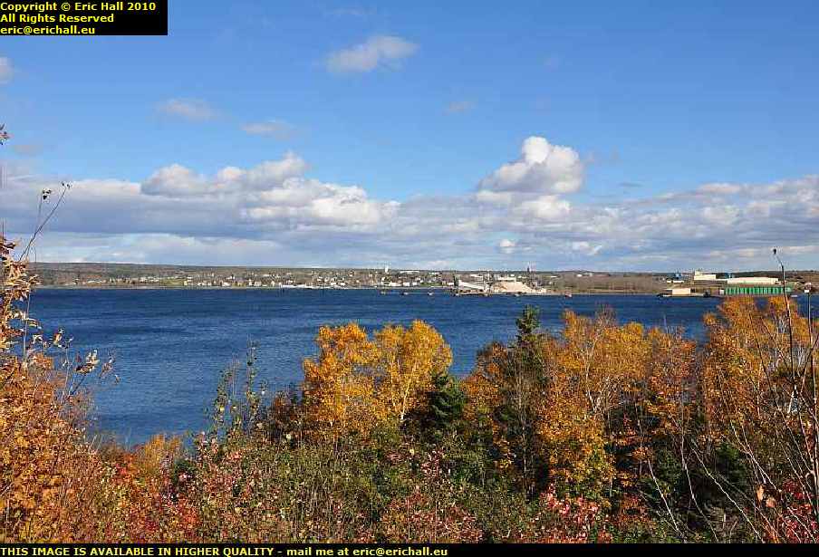
The second photograph that I took from up here was across the Strait towards Port Hawkesbury and Port Hastings. There's considerably more maritime activity going on there as you can see, with many more facilities than at Point Tupper.
If you look slightly to the right of centre along the coastline you will see what look like coal staithes on the dockside. They would run railway waggons, loaded with coal, up the ramps of the staithes and then tip the contents down a kind of slide into the hold of the ships tied up below the chutes.
There were coal mines along the north-west coast of Cape Breton Island in the Inverness area but that part of the Island has no deepwater ice-free port for larger ships. A railway, the Inverness Coal, Iron and Railway Company. ran from there down to a junction at Port Hastings and then down to the docks at Port Hawkesbury. Of course, the coal and the railway down from Inverness have all long-gone now.

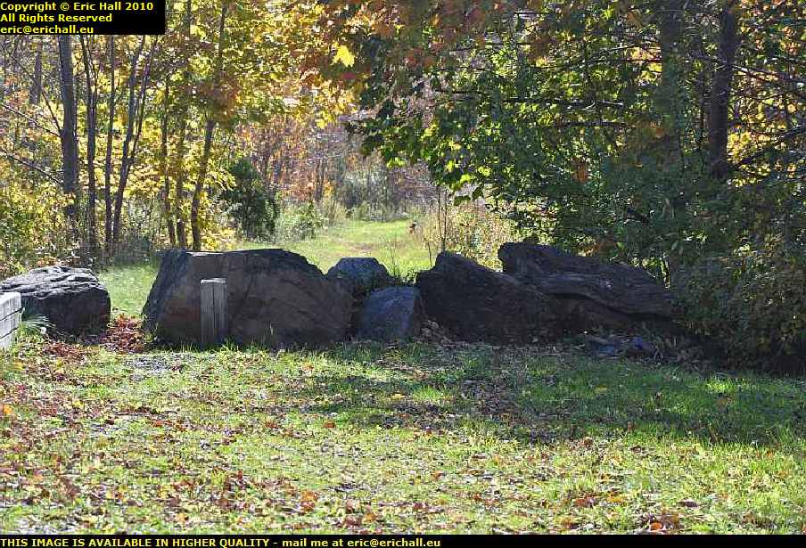
While I was up here I had a quick look behind and here I am with the old abandoned railway again. It seems that it continues on past Mulgrave because we are well above sea level here. There doesn't seem to be all that much south of here and so I wonder where it might be heading to and, more importantly, why.
It's one thing that I have difficulty understanding as I travel around Europe and North America. Back in the UK there's quite a thing about abandoned railways. Their history is minutely logged and every last detail has been carefully recorded. Anywhere else, there seems to be little interest at all.
Where I live in France, I'm engaged on two projects for the local history society researching the two railways (one a standard-gauge line and the other a metre-gauge line ) in my area. And even though they were both open and running well within living memory - and if you know the Auvergne, you'll know that the average age of the inhabitants is much older than anywhere else in the world - no-one can recall anything and even worse, neither do they seem to care. The mother of one of the guys on the History Society committee actually worked in the local station, but he comes forth with nothing at all about her activities or any other personal reminiscences of the line.
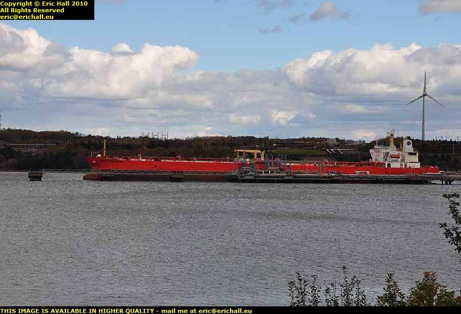
There was a vessel moored at the quayside and so I went for a wander down there to see what it was. Due to chain-link fences and barbed wire and the like I couldn't get too close to it but I managed to take a good photo of it.

It's called the Arctic Endurance of about 2800 tons, a stern trawler of an individual design built in 2000 by a Norwegian company called SøViknes Verft.
It's registered in Halifax, owned by a company called CS Manpar Inc, and operated by a company called Clearwater Seafoods Limited Partnership, "Dedicated to Sustainable Seafood Excellence" and thereby hangs a tail. Strangely enough, these two companies share the same address.
The state in which the fishing industry off the Eastern Canadian coast finds itself right now, which company has the money to invest in a brand new stern trawler of this size, espcially when there must be any number of good modern trawlers laid up all over the place ?
And then, why go to Norway to have it built when there are dozens, if not hundreds, of equally-good local yards all up and down this coast? The company's own Charter of Corporate Social Responsibility
"implies a commitment to the country" and is "engaged and active with community involvement efforts"? Mind you, I can't ever recall a website being so full of rhetoric and so short on factual data. Perhaps I just didn't look hard enough.
But about all of this fishing business off the coast of Eastern Canada, I smell something fishy, and I'm not talking about the contents of the hold of the Arctic Endurance either. If this company can make what would seem to be a decent living out in what is left of the fisheries of the western North Atlantic, then so should everyone else be able to, with the same kind of commitment.
The answer to this enigma is, of course, quite simple. It's none of my business.
And don't quote me on this, but all of that down there looks like an old car ferry quay. Maybe it is where the old ferry sailed from, but maybe it isn't.
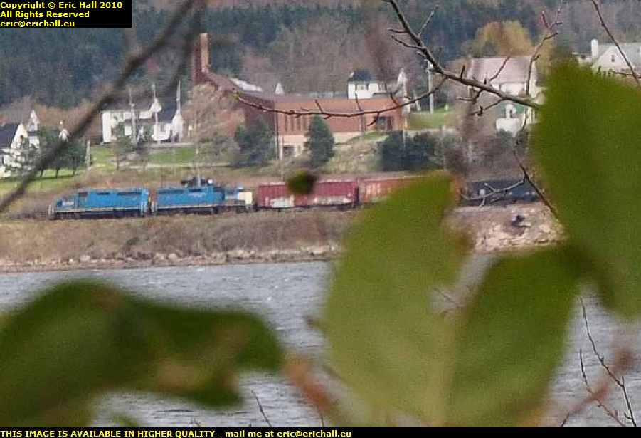
Whilst clambering back up to my spec on top of the hill at the back of Mulgrave, I heard the most enormous racket coming from across the other side of the Strait. Peering through the trees I could just about make out a couple of railway engines dragging a huge train of stuff over there, far too far away for me to be able to identify what type of locomotives they might be.
I remember thinking to myself that I hope that photo comes out, because all of the trees and so on in the way might obstruct or blur the image, but biding my time I managed a clear shot through the branches. The enlargement hasn't done the image any favours unfortunately and it's not as sharp as I would have liked, but I've not seen a train since I was on the way out of Labrador City a lifetime ago, and I've been having withdrawal symptoms.
From here I moved on southwards to go for a nosey at the wind turbine at Point Tupper, which you can see in the photo just here. What is surprising about this turbine is that it is the first one that I have seen on the whole of Cape Breton Island this year, although keen readers of this rubbish will recall that we encountered one near Cheticamp on our journey in 2003, and with all the wind that there is around the Maritime coast I find that totally astonishing. Why have a coal-fired plant when there is no more coal to burn but there's all this wind?
There's also a huge tanker - the Eagle Baltimore - anchored in the harbour. There is an oil refinery over there somewhere and so my money was on her being an oil tanker. However, when I asked her what type of ship she was, she told me to **** off. Ahh yes - a crude oil tanker, of course.
While I was musing on that, I got back in the car and drove off, and the first thing that I encountered was a sign telling me that there was a liquid natural gas pipeline passing underneath the road. I'll talk about this pipeline in due course because a little further on in my travels, I ecountered it again.
Another thing I was musing on was how much this area was tied to the sea. Almost every place I've seen along the Maritime coast is Someone's Harbour or Port Someone Else. It's the same almost anywhere that you go along the coast. The whole life of everyone that lived here was ruled by the sea and it makes you realise now how much devastation there has been with the collapse of the cod fisheries on the Grand Banks. A far cry indeed from John Cabot's famous
"... the cod were so plentiful that they sometimes stopped our ships."
The road that I had been following along the coast was Highway 344 described as some kind of Coastal Path, and I do wish that I wouldn't mumble into my dictaphone, but soon I rejoin Highway 16 which is the main road down to Canso, which is where I'm headed.
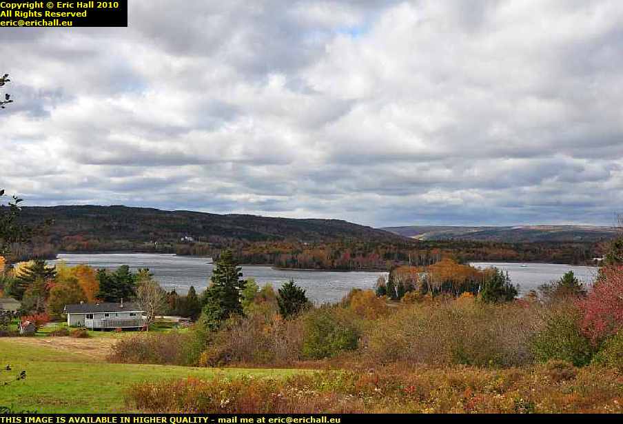
At Boylston, probably not 200 metres from where I rejoin the highway, I have to stop and double back to take a view of the scenery just here. This is an inlet of the sea - the mouth of the Milford Haven River and head of Chedabucto Bay.
Now this view was worth the price of the admission, I reckon. It really was beautiful and the late October colours were magnificent. It's quite a contrast from its namesake in South-West Wales. There's not an oil tanker or refinery for miles around - "except at Point Tupper just up the road of course" ...ed.
This little area was full of nice little coves and rivers and so on. Definitely what I would call picturesque or photogenic.

Do you know - I can't remember where it was that I took this photo. I didn't record the name, presumably because I was so enthralled by the view. Judging by the map, it might well be Guysborough but I'm not certain about that.
The street just here is called Pleasant Street and beautiful though it might be, I couldn't see why this street should be singled out more than any other because all the streets were pleasant round here. Guysborough, if that's where it is, is built in the style that I call "Pioneer Wooden" and I reckon that it is one of the finest examples of "Pioneer Wooden" architecture that I have seen.
By now I was almost starving to death. It was mid-afternoon and I hadn't yet had lunch, and I'd been on the go since about 05:30 this morning. I'd seen loads of pretty places and loads of car parking spaces, but never the two combined.

Just outside Guysborough though there was a quiet kind of Provincial Park with a lake and some kind of nature trail, and a little half-hour rest just here would do me the world of good. There were some bread rolls, tomatoes, lettuce, bananas and root beer in Casey. Add to that the water, the sunshine and a little peace and quiet - what more could any man desire?
But take a look at the nature trail just here. That's something else that has "abandoned railway" written all over it. I wish that I could find some kind of comprehensive railway map of Eastern Canada to show me where all these lines were and where they went to.

And so having stopped in a Provincial Park for lunch because I couldn't find anywhere with a decent view, what do I find just about half a mile down the road but a parking place with a decent view of the sea? You might have expected something like that - it always happens like this.
Anyway we are looking out along the shore of Chedabucto Bay down towards my destination. I drove around the other side of the bay of course a little earlier but I really don't remember the view from over there being anything like as good as it is from here. How strange.

A short way further on, there's another place to stop and admire the view across the bay, and this is a view well-worth stopping and admiring too, as you can see.
But more importantly, this site is said to have some kind of major historical significance. It is claimed by some (and vehemently denied by others) to be the first landfall of Europeans (wandering Irish monks and even the Vikings excluded) on the North American coasts.
Let me set the scene for you, and turn the clock back almost a thousand years to the First Crusade to Jerusalem. After Jerusalem had fallen to the Crusaders and a European king installed, a small group of knights came forward. They told the king that they intend to patrol the route to Jerusalem in order to make it safe for pilgrims. The king agreed, and gave the knights some comfortable quarters at the site of the old Temple of Jerusalem.
Now the road to Jerusalem is measured in thousands of miles, yet no-one questions how these knights are to secure this road and protect the pilgrims, seeing as there is only a handful of them. Nevertheless, being as they are installed in the Temple, they adopt the name of "The Knights Templar". Now instead of spending their time securing the road, they stayed within the old Temple, where contemporary rumour had it that they spent all of their time in making excavations amongst the ruins.
All of a sudden, the Templars became rich - rich beyond the dreams of anyone living at the time. Their number expanded greatly, each new knight assuming some kind of increased wealth. No-one has ever satisfactorily explained the source of this wealth, just as no-one has satisfactorily explained what happened to all of the treasures of the Jewish State when Jerusalem, including the Temple, was sacked and pillaged by the Romans in AD66.
The wealth of the Templars excited all kinds of jealousy and eventually the Pope ordered their excommunication. A crusade was launched against them and in most European countries they were ruthlessly hunted down and exterminated. Many Knights Templar fled and were never found, and no-one really knew where they went. Round about this time, Scotland was a very closed society and never paid much attention to Papal Bulls. It is also round about this time that Scotland started to have its most successful period of warfare against the English, with the Battle of Bannockburn and all of that. But any conclusions drawn from all of this are mere speculation.
One of the major reasons given subsequently for the suppression by the French of the Templars there was that the French King coveted the enormous wealth of the Templars, but this wealth was never found.
One is tempted to read something into the story of the Seige of Montsegur, a Templar stronghold in Southern France. The Templars, having been beseiged in their castle for quite some time, agreed to surrender their castle, but only after a certain date. On the eve of that date it is known that two defenders of Montsegur escaped, and that on the following morning the remaining defenders opened the gates, and were massacred without a struggle.
Shortly after this, one of the Templar ships in the harbour of La Rochelle set sail, and there is no record of it coming into port anywhere else.
And there you have a very condensed version of what is the Enigma of the Templars.
The Templars of course set themselves up originally as the Defenders of the Christian Faith, and who they were defending themselves against of course were the Muslims. As an aside, the literal definition of a Crusade is "a war to defend the Christian Faith against the Muslims" and that is why the Bushbaby's stupid remark about "Going on a Crusade" after the events at the World Trade Centre reverberated around the world and made bitter enemies of so many people who otherwise would not have cared less about whatever the Americans and their British lackey running-dogs were doing - but I digress.
Anyway, back to the story. Spain had been occupied by the Muslims for ... ohhh ... 600 years but in the 15th Century the Muslims were slowly being pushed back across the Mediterranean. This had cost the Spanish a fortune and the King and Queen of Spain, Ferdinand and Isabella, were desperate for money. Along came an adventurer, Christopher Columbus, with a cunning plan to go to "The Indies" and bring back the wealth. Eventually, after much discussion and debate, Ferdinand and Isabella agreed to finance his voyage.
Columbus clearly had no intention at all of going to "The Indies". Any scholar of that date, and almost any scholar today, could say with 5 minutes of research and calculation how far it is to the Indies around the Equator going from east to west, and how long it would take to sail there. But Columbus has a map, that is beyond dispute, and he also definitely knew the secret of the tides and ocean currents, an astonishing thing seeing as how no-one is supposed to have gone there before him, and he took only enough food and water with him to reach the Gulf of Mexico.
The Gulf of Mexico, teeming with gold, silver and jewels as we know from the tales of Cortez and his contemporaries, abounds with legends of white men with beards having been there well-before the Spanish arrived, but Columbus fetched up on a poor impoverished island. Had he gone just 20 miles either side of this island he would have been in the open waters in the Gulf of Mexico and the world would have been his oyster. Nevertheless, an error of navigation of just 20 miles in 1492 with the primitive charts and navigation equipment that they had in those days and over the distance that he travelled is a remarkable feat of navigation all the same.
But what treasure was it that Columbus was hoping to find? Is it a pure coincidence that white men are said by the inhabitants to have been to the Gulf of Mexico prior to Columbus? Is it a pure coincidence that the ship of the Templars, that left La Rochelle and may or may not have been carrying the Templar treasure, was never seen again by Western eyes? And is it pure coincidence that the sails on Colombus' ships were not plain white, were not covered in emblems of the King and Queen of Spain, nor covered with any lucky charms or insignia, but were the simple red splayed cross on a white background that had long been the emblem of the Templars?
But what this all has to do with my story, I really have no idea.
In Scotland in the 14th Century lived someone called Sir Henry Sinclair - the name Sinclair being of course the Anglicised version of the French Saint Clair. He lived in a small place called Rosslyn, just a handful of miles outside Edinburgh, and there is a magnificent chapel there that dates from the time of Sinclair's grandson. When Rosslyn Chapel was built, people stared in wonder at the designs in the stonework and in the windows, as they looked so surreal and exotic. No-one had ever seen anything like them at all.
Sinclair's explanation was that he had simply copied things that his grandfather had seen on one of his long sea-voyages. Henry Sinclair did indeed travel on long sea voyages, but never went into too much detail about many of them, and this reticence may not be so surprising.
It is well-known that Sinclair had business at the Court of King Haakon VI of Norway, persuading that latter to make him Earl of Orkney. With Orkney being a dependency of Norway at the time, Sinclair would have become a subject of the King of Norway. He certainly visited Haakon's Court on several occasions thereafter, and therefore voyages in the Far North Atlantic would be of no uncommon thing for Sinclair, just as for many other habitués of Haakon's Court.
There can be little doubt that whilst at Haakon's Court Sinclair would have heard about the old Viking colonies on Iceland and Greenland. During this period there were well-documented slave raids to the dying Norse colonies on Greenland, so much so that the Pope had threatened the most severe sanctions upon anyone engaged in the trade. It's not surprising therefore that there was a great reluctance for anyone to admit taking part in the raids, but there is no question whatever that they took place.
It is also well-known that the deterioration of the weather in the far north due to the onset of the Little Ice Age was causing all kinds of unpredictable sailing conditions in that region. In 1347 an expedition from Greenland to fetch timber from "Markland" (without doubt the coast of Labrador - there is nowhere else in the vicinity where worthwhile supplies of timber might be found) ended up in a port in Iceland after all kinds of struggle against the elements. It is of course also well-known that the Vikings discovered the coast of North America 350 years earlier by being blown off-course in bad weather.
It is therefore an absorbing kind of pastime to knit together some kind of story about how it might be that Henry Sinclair was blown off course during one of his adventures in the North Atlantic, and ended up on the coast of North America.

There is a suggestion - and I put it no stronger than that - that during one of his voyages, Henry Sinclair arrived at the coastline of North America and according to The Prince Henry Sinclair Society of North America, a description of a possible landing site corresponds quite closely with this area of Chedabucto Bay.
To celebrate the 600th anniversary of his landing, they caused a memorial to him to be erected here. It's worth a visit for the scenery alone, no matter what credence you give to the story of his adventures
Regardless of whether you are for or against the idea that Sinclair came to this part of North America in the 14th Century, there is some surprising "evidence" to support the idea of Europeans being here long before John Cabot, and that is from one of the Mi'kmaq legends, the Mi'kmaq being the predominant native American tribe from this area.
This particular legend concerns the god Glooscap, who is said to have built himself a large wooden canoe and to have planted trees in it. You might think that that is a strange idea, but a more-compelling image of the construction of a "European" ship and the installation of masts as seen through the eyes of an untrained observer you could never ever imagine.
Mind you, this could apply to any European ship, not necessarily one of Henry Sinclair. It has long been contended that other Europeans - Portuguese fishermen, Basque whalers, Viking explorers, Irish monks, British slavers and so on - were discreet visitors to the North American coast before Cabot, not to mention Medieval Greenlanders who, without doubt, made voyages here to collect timber, one such voyage we discussed earlier.
Not only that, it was reported by Henry Hudson that in mid July 1609 while on his voyage to what became known as the Hudson River, he stopped somewhere near LaHave in Nova Scotia to replace a mast on his ship.
But as for the earlier, pre-Cabot visits, there is some surprising confirmation. Prior to the rediscovery of North America, beaver pelts offered on the market in Europe came mainly from Russia and these were treated in a specific way, but occasionally, European markets offered for sale other pelts that had been treated in a different fashion.
It wasn't until the early days of the Hudsons Bay Company that people realised that these mysterious pelts that had been offered for sale in the 13th 14th and 15th Centuries were treated in exactly the same fashion as those obtained by the Company from the indigenous North American inhabitants.
No matter where you go and with whom you talk, you will not find many topics more controversial than those of Henry Sinclair, the Templars and the discovery of North America. Everyone has his or her own opinion based upon facts selected or discarded at will, and sometimes not based upon facts at all. You should not therefore take any of this too seriously. No-one knows the answer. Half of the people don't even know the question.
So having added more fuel to the fire on the Great Henry Sinclair debate, and having given the pot another good stir, we can move on down the road. Next port of call is the entrance to the bay at Queensport.

Sitting on an island in the mouth of the bay - is it Rock Island or Rook Island? I cant read my own handwriting here - is an extremely quaint lighthouse.
It's the Queensport lighthouse, originally built in 1882 out of wood, like everything else round here, and was rebuilt in 1936. I imagine that its purpose would be to guide mariners to the correct side of the headland and the island depending upon whether they were visiting Queensport or the nearby Philip's Harbour. It's automated now of course but until 1967 there was a keeper.
Strangely, it exhibits a red light from a lantern, originally fuelled not by whale oil as you might expect but by paraffin, and now of course by electricity, on the roof. I suppose the red light is something to do with sending a certain signal to sailors home from the sea after a lengthy voyage.
Not too far on from here they are fixing the roads down to Canso and by the looks of things I can't say that it is before time either, because these roads are pretty dreadful. Although the roads are metalled, they are patched everywhere and even the patches have patches. In fact, this road would not be out of place up on the Upper Labrador Plateau .
Still, needs must when the devil - or Yours Truly - drives, and I want to go this way, and for a specific reason too, as you will shortly find out.
©