|
CHEMIN DU ROY |
|
|
CHEMIN DU ROY |
DESCHAMBAULT
Our journey brings us to the town of Deschambault, which has a Saturday market from 09:00 - 13:00, so all of the thousands of adverts and signs here tell me
In 2012 I drove through Deschambault without taking too much notice of the town. It clearly couldn't have made that much of an impression on me, but then I do remember that it was late in the evening and I was rather preoccupied with looking for a place to stay. The whole purpose of coming back in 2013 was to catch up on what I had missed - always assuming that the weather would let me. -
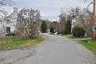
I went for a good prowl around on the outskirts and noted two traces of road that were running parallel to the modern road, both of them on the south (river) side. One of these is right at the cliff edge (we are quite high up) but if this had been an old trace of the Chemin du Roy then the western end would seem to have been the victim of an extraordinary amount of coastal erosion.
As for the second one, what might have been the eastern end of that trace is covered with old trees and huge rocks and it is therefore difficult to see how a road could have continued on from that point.

Generally speaking (believe me, we have seen plenty of exceptions on our travels) the centre of any settlement is where the church is situated and so it's always a good idea to head for there.
The church at Deschambault, dedicated to St Joseph, dates from 1837 and was designed, both the interior and exterior, by Thomas Baillairgé who we have met before ... "and will meet again" - ed ... and who was the son of Francois who we met at the prison of Trois Rivieres and divers other places on our travels.
The mason was Olivier Larue and Francois-Xavier Normand was the carpenter, just in case you were wondering, which I'm sure that you were.

You'll notice that the church is not square-on to the line of the road (which passes to the right) as you might expect, but this is not the original church of the town. There was an earlier one at Deschambault, dating from 1735 (and that date is significant, being the year after the completion of the Chemin du Roy) and that was situated in what is today the car park.
We aren't told what happened to the church of 1735 but I'm sure that anyone who has travelled around the Province of Quebec with me via the medium of these pages will be able to have an inspired guess.
There was also a convent in the town - a big house by the side of the church. I wonder if it might have been that house to the left. But I shall have to get out of the habit of speculating - we're having nun of that here.

If my speculations are correct, the old trace of the Chemin du Roy is that to the left of the magnificent stone building just there. That may well be the Old Presbytery dating from 1815 and subsequently restored.
I should perhaps mention that to see a stone building in North America is something rather noteworthy - most places being of timber construction. Here where I live, stone buildings are the norm. Everyone, even Yours Truly, lives in a stone house and so we don't have the same enthusiasm for them.
Mind you, having restored my own, including rebuilding a wall that had collapsed, I can appreciate the work that goes into building them.

Walking along the road a little way, I turn back to take another photo of the Old Presbytery. Yes, this certainly looks like the trace of an important road and the dimensions that we know from Lanouiller's notes certainly fit in with what we have here, even down to the ditch on the left-hand side.
As an aside, it's said that one third of the houses in Deschambault are at least 100 years old. There would have been four more too, had it not been for a fire that broke out here in 1922. It seems that the Province of Quebec has quite an incendiary history, in many senses of the word, and unfortunately the toll continues to mount

Now did you notice those stones that were being used to line the garden on the right in the previous photo? I don't know about you, but they looked quite suggestive to me so I went over for a closer look. Here's a photo of a typical one, nicely carved and engraved with a religious symbol.
Hmmmm.
With the old church having been demolished and with very little, if any, of the exterior work being reused in the replacement, it did make me wonder whether or not these stones might have been recovered from the demolition site.
Eternal optimist that I am, I did have a close look for signs of scorching, but after 180 years or so that was probably being rather too optimistic

Continuing our walk eastwards around the headland (which I am told is Cap Lauzon) towards the modern highway, my attention is drawn to the trace of what might have been a track or road down the slope to the right of the existing road, hard up against the hedge.
That seems to want to do its best to continue in our general direction and so one might propose a theory that it could have been the original trace of the Chemin du Roy, subsequently abandoned as being too close to the cliff. We know that a considerable number of stretches of the original road have been abandoned, for all kinds of reasons.

Carrying on, we rejoin the modern Highway 138 a little further on and here, in an almost-perfect alignment with the old road down which we have just walked, is another deviation of the road. You can see the modern highway to our right.
And what do you think of the Dodge? It has miraculously transported itself here to meet me. Well, either that or Strawberry Moose has driven it down to meet me.

A little further on, we can see ditches. Lanouiller ordered his road to be lined with ditches such as there, so as "to aid with the drainage", and those trees down there lining the side of the road, they have not sprung up merely within the last 50 years.
A further clue is in the name of this road. It is in fact called the Chemin du Roy and although just like tourist venues, we should never accept at face value whatever name a local council gives to objects under its control, I reckon that in this case we can be reasonably sure of ourselves.
But whatever happened to the Province of Quebec's assurance that "some kind of authenticity to each site that is visited" will be given?
We have a couple of challenges on our journeys around North America.
It's getting on for 18:00 and here we are at the banks of one of the most important waterways in the world and we have yet to see a ship today.

However, walking back to the church and the Dodge, we soon put that right as the Maersk Pembroke goes sailing (or, rather dieselingr) past us on her way to Montreal from Vlissingen in the Netherlands.
Owned by the Maersk Line and registered in the Netherlands, she was built in Germany in 1998 and grosses about 31,500 tonnes. Flat out, she can do 22.5 knots and has a draught of 9 metres.
And what wouldn't I have given to have had Caliburn in one of the containers on the back? Hiring a vehicle for every time I come over here is becoming less and less cost-effective.

On blowing up the photo, because I can do things like that despite modern anti-terrorist legislation, I find that we have two for the price of one as the Maersk Pembroke is busily engaged in overtaking a small sailing ship.
I wouldn't like to have been in that sailing ship, I can tell you. I'm not a very good seaman ... "seaPERSON" - ed ... and that looks like quite a close call to me. And I bet that they will have a rough ride when they encounter the Maersk Pembroke's wake.

Now being reasonably satisfied about the easterly trace of the old Chemin du Roy through Deschambault, I suppose that I had better look at the western end of the road to see what I could see.
Sure enough, there is a track that heads in a straight line out westwards and follows the line of the cemetery. This is now starting to look quite optimistic. But take note of the cemetery wall for I'll be talking about that in a minute.

Do you remember right at the very beginning of my visit that I mentioned a likely-looking road where "the eastern end of that trace is covered with old trees and huge rocks and it is therefore difficult to see how a road could have continued on from that point"?
The western end of the track that I am on likewise peters out into an area "covered with old trees and huge rocks" and as I fight my way through the undergrowth, I find myself staring at the aforementioned spot.
Well, well, well.
I haven't finished with the town yet, though. There's a house here, a plain, banal house of no real note but we are proudly informed that a curiosity of the building is that it has no overhead power cables going to it.
One assumes of course that all of the power cables thus pass underground, but I'm not sure why that should be considered a curiosity as in my mind it makes much more sense to have subterranean cables, especially in urban areas prone to heavy snowfall. It beats me why nowhere else in Canada that I have ever visited, apart from Amherst, Nova Scotia, does this.
To my mind, it's certainly not something noteworthy.
My attention was also drawn to a list of notable families who came from this area. One of the names on the list was the rather unlikely name of "Nau". Not a name of French origin at all but then on the other hand I did once meet a girl called Erica Nau so I suppose that there is something in this.
But the most interesting part about the town as far as I am concerned is the history of its fortifications.
At the height of the issues with the Iroquois in the 1630s, Champlain decided to build a fort here to protect the area from incursion. It is said that he constructed a fort on an island in the river just below the town, close to the Rapids of Richelieu.
The area was however refortified during the Seven Years War and then following the collapse of French North America, General Murray chose Deschambault as site of a fort. The area was also defended by an American occupying force (with the aid of a few of the locals) in 1776, and in 1794, at the start of the Napoleonic Wars, Deschambault was chosen to be the site of a large fort to be built to protect the approaches to Montreal.

I had a good wander around to see whether I could find any vestiges of any defensive works, but I wasn't too optimistic after over 200 years. Consequently I had a good look to see if there was anywhere that suggested itself as a likely spot for a fort.
My eye was caught by this little eminence here at the back of the car park. It's the highest point in the immediate area and if you were to hack away the bushes there would be a clear and uninterrupted view of the St Lawrence right the way down to the meander at the Pointe au Platon just a few miles downstream.

That eminence might not have looked very much in the previous photo, but here's a photo taken from a different angle, in which you can see that it is quite a worthwhile slope to defend. A ditch with glacis and revetments could turn this site into something of a tricky proposition for any attacking force.
I don't know if you can quite make out the St Lawrence through the trees at centre-left.

And this is what you find in the dead-centre of every town - the local cemetery. All cemeteries have walls around them because, of course, people are dying to get in there, but in this case the wall on the right-hand edge of the photo is the wall (lined with a hedge) to which I drew your attention just now.
The cemetery is actually at the foot of our little eminence and so if one assumes that the eminence were to be fortified, the position now occupied by the cemetery would have been part of the defences, as would the wall, and so the wall would actually pre-date the cemetery.
As an aside, I'm sure that you are wondering what happened to the British fleet that sailed up here in 1760 to Montreal. The answer to that is that the gunners in the French defences had the British ships firmly in their sights but just as they were about to fire a devastating salvo at the ships, a sudden gust of wind blew them past the fortifications quicker than the French could realign their guns.
Divine intervention of course. Clearly God was on the British side.

That was enough of Deschambault for now and so I rejoined the Chemin du Roy to continue eastwards. However, a couple of kilometres out on the other side I was sidetracked however by a road sign that indicated Les Moulins de la Chevrotière.
That had to be worth going for a wander, I reckoned. From up here it all looked quite impressive.

Before I did so, however, I went for a walk along the road bridge over the river, the Rivière Chevrotière. It's a modern realignment of the road with a modern concrete bridge of no particular merit, but the view from the bridge of the confluence of the river with the Hudson (Hudson? Hudson? That's a Freudian slip if ever there was one) … errr … St Lawrence was worth the price of the admission.
This photo was taken in April 2012 and I remember making the comment right at the beginning of that journey that trying to do this in the spring before the leaves appeared and obscured the view might well be worth the freezing to death in the bitter weather. It seems that I'm being proved right.

I mentioned, didn't I, that the bridge over the river here was quite modern, and that it seemed to be a modern alignment of the road. Turning off down to the mill, I noticed this trackway that comes in from the side that seems to line up perfectly with the older bridge that you saw in one of the photos above.
This would appear to suggest that this is the line of the Chemin du Roy from the period before the modern realignment and judging by the position of the mill and the bridge, it might even be part of the 1734 alignment, although nothing is certain.

So what about the old mill, then, with the river running close by to the left?
Firstly, I said moulins because there are in fact two. The first one, the smaller of the two, was built in 1767 and the second one, the one in this photo, was built in 1802 according to one source and 1830 according to another. Anyway, regardless of whatever date it was built, both mills now house a museum of local interest as well as being some kind of school for woodworking and stone-masonry.
As an aside, we've seen this on so many occasions in Québec - different dates being given by different authors for the same event. Local history appears not to be something taken very seriously around here

Meantime, back on the road a mile or two further on there's another spectacular view across the river. I spy with my little eye another church way over there and the big telephoto lens does its stuff.
It's hard to say which village it is over there, but I did once see a drawing of the church of Saint Louis in Lotbinière and the upper works of this church in the photo resemble quite strongly the church in that drawing. I can't say any more than that about it.
If it is the Church of St Louis, then it is said to be one of the most richly-decorated churches in the whole of Québec. Makes rather a mockery of "give all thou hast to the poor" and "thou shalt make no graven images". It does remind me of the church in Bruges in Belgium that is said to spend more on the security to guard its Michaelangelo statue than it gives in alms to the poor.
Anyway, back in 2012 the gloom was a-gathering and I still hadn't worked out what I was going to do for the night. This was something that I needed to resolve without further ado.
©