 | CANADA |
TADOUSSAC
At the other side of the Saguenay River is situated the small town of Tadoussac. I was here, as I have said before, a couple of days before New Year's Eve in 2001 but it was dark when I arrived and dark when I left so I didn't manage a decent photo of the place.
I always try to take a photo of the place where I stayed too, but that didn't work out very well either given the camera that I was using.
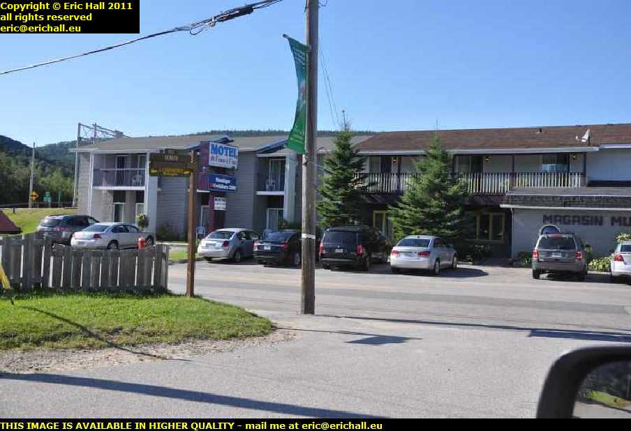
No such issues today, though. Here is the aforementioned. But it has to be said that the advantages of taking photos in the dark is that you can't see the electricity pylons.
There was not one acceptable shot of the Motel de l'Anse a l'Eau that did not have a pylon in a crucial part of the image.
Ohhh for underground cabling! If they can do it at Amherst, why can't they do it anywhere else?
And ohhh for detachable wing mirrors on Dodge Grand Caravans too.

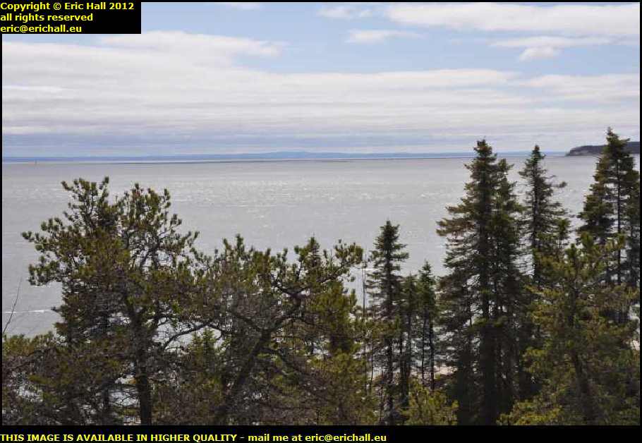
At the top of the hill on Highway 138 there's a good spec to park up and look back down towards the mouth of the river that I had just crossed over on the ferry. And with the weather improving bit by bit, the view was quite impressive. One of my favourite photos of all time, this.
But here's a thing. I am the first to admit that do some strange things with my camera, such as pointing and clicking as I'm driving about the countryside. But that's in a car, and so I was rather intrigued to see this motocyclist go by, with one hand on his handlebar and the other hand holding a compact digital camera in front of his face taking a photo of the bay.
And I bet that you thought that I was crazy.
When I was here in 2010 I was in quite a hurry so didn't stop for a look. And in 2011 I had other things on my mind. However, revisiting the town was always something of a priority and so in 2012 I finally did manage to fit into my hectic schedule a visit to the town to retake the photos of my 2001 visit.
There is, however, something that I need to do first.
I told you earlier that I flew (well, I didn't - I was in an aeroplane and the aeroplane flew) over a sandbank in the St Lawrence in 2011 and there was one just offshore at Baie St Catherine that was a likely candidate.
I found the footpath around the coastline where I walked late that night in 2001. From up here I have a much better view of the aforementioned. And I change my opinion about it, because I think that it is curving in the opposite direction to what I remember.
And in any case, I found an even better candidate futher up the road.
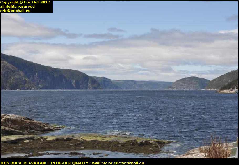
There's a stunning view of the Saguenay River too from here, and this view answers a question that I asked a short while ago.
While we were sitting in the queue for the ferry at Baie St Catherine a couple of pages back, I was discussing the possibility of bridging the Saguenay River. However, from here, you can see why it hasn't been done - for which I am grateful.
There's an enormous amount of industry up around Lac St Jean at the head of the Saguenay River, and so the river is something of an important seaway. Quite a bit of maritime traffic - big freighters, make no mistake - make their way up there to the various ports, including the enigmatically-named Baie des Ha!Ha!
How much height do you need to get from this particular point to give enough headroom to a large freighter? Of course you could go up and off and over from up on the headlands around here but that would still be something of a massive engineering project.
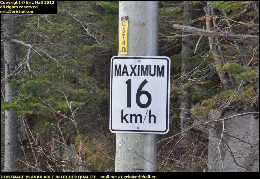
Returning to the roadway to continue our little walk around, this little sign catches my attention. You don't need to be a demon at maths to work out what the speed limit here used to be before Canada adopted the metric system.
However a speed limit of 16kph is totally inappropriate. With speedometers being marked in 10s, why not make the limit 20kph? Or if they are marked in 5s why not make it 15kph? How are you going to tell what is 16kph on a normal speedo?
The area around Tadoussac and the Saguenay River had been explored on several occasions by Champlain and Roberval during their respective voyages of the 1530s and 1540s, and in 1544 is the first recorded evidence of the establishment of fisheries at Tadoussac by Basque fishermen - although it is suspected that they were in Canadian waters - not necessarily here, though - much earlier than this and probably even before Cabot's voyages of discovery in 1497.
It was in 1600 however that Tadoussac became a place of importance. An expedition led by Francois Grave du Pont and Pierre de Chauvin de Tonnetuit received a forfeited Royal Commission from the King of France to trade in this area for fish and furs.
They arrived here in 1600 and built a small fortified trading post 4 toises long by 3 toises wide (a toise being 6 feet - or less than 2 metres as they hadn't gone metric in their day) as a base for contact with the native Montagnais. The building that you see here is not the original one but a reproduction, built in 1942 on what is believed to be the original site
Anyway, the first season's trading was quite successful and by Autumn they had a ship-load of furs ready to depart for France. Grave de Pont and Chauvin therefore returned to France with their cargo, leaving 16 men behind to continue the liaison with the Montagnais. However, when a ship returned in the Spring, it found only 5 of those 16 men still alive, and they were evacuated.
Chauvin returned to trade during the summer of 1602 but did not over-winter here and Champlain, during one of his visits here in 1603, moved the trading post elsewhere.
The next date of note is 14th June 1617 when Louis Hebert, described as "the First Farmer in Canada" arrived at Tadoussac with his wife Marie and their three children.
However it fell into British hands in 1628, but was subsequently restored.
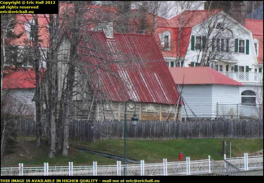
So continuing our pleasant walk around the bay because here I'm out of the bitter north wind. It's perishing when your north side is exposed but beautifully comfortable in the sun and sheltered position.

The big building in the background is the Hotel Tadoussac, and hereby hangs a tale. Instead of freezing to death and dying of scurvy, why didn't the 16 men left behind in 1600 go and book in at the hotel? That would seem to be the logical thing to do if you ask me.
The little wooden church to the right is the Chapelle des Indiens. It was built in 1747 and said to be the oldest in North America - all the other ones having burnt down, one imagines. There was an earlier church on the same site, built in 1641, but only the bell survives. That's in the present building.
By the end of the 19th Century there were about 20 or so families, mostly fishermen and whalers, living right out here on the point at Tadoussac but they were moved on because they did not have any title to their property.
That, of course, begs the question "who DID have the title to their property back in those days?"
And lots more questions besides, such as "where did one go to obtain a title?" And "why didn't these people obtain a title for the land here when there were other people obtaining titles for other places elsewhere?".
But talking of whalers does remind me of a little story that I have been dying to tell for ages.
You might know that back in the 1970s I played bass guitar to quite a high standard (and I still have all of my gear) and when I heard that Bob Marley was looking for new musicians for his backing group, I was amongst the eager applicants.
However I did feel rather silly. I was the only one there who had brought his own harpoon.
Rather than rejoin the modern main road, there's the old road out of the back of the town. That looks much more interesting.
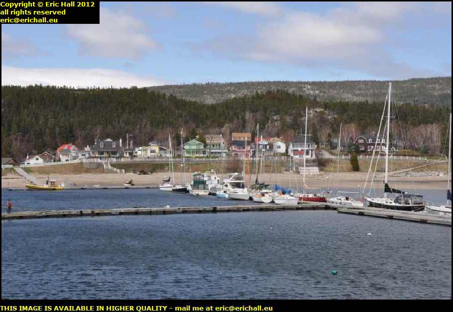
I mentioned on a previous page that Tadoussac is something of a favourite spot for tourism in the summer, famous for its dunes and beaches since the creation of the coastal steamships in the 1850s.
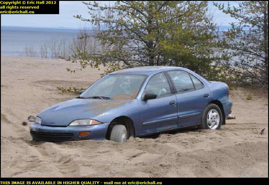
But if you do come here in a car, this is one thing that you always need to be careful of because you might end up with serious problems like the owner of this vehicle. You'll need more than a tractor to pull this out of here. It looks as if it's here for the Duration.
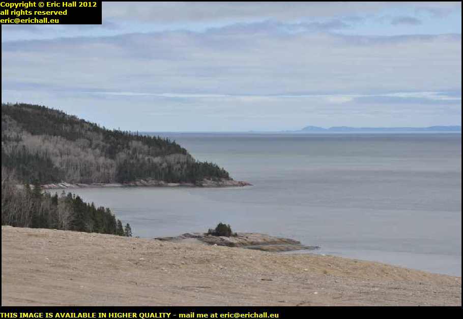
Even in early May the scenery looks quite beautiful, and the view across the St Lawrence to the Ile Verte and Trois Pistoles looks quite spectcular despite the overcast conditions and the lack of leaves on the trees.
But just a little word of warning.
Shell fishing is banned along here due to contamination of the water. And if it's not healthy to eat the shellfish, then it's not going to be very good to swallow a mouthful either.
From the bay the choice is to go back to the town or else follow a rough little road that looks as if it heads in the general direction of the modern Highway 138.
Of course I chose the latter. In for a penny, in for a pound!
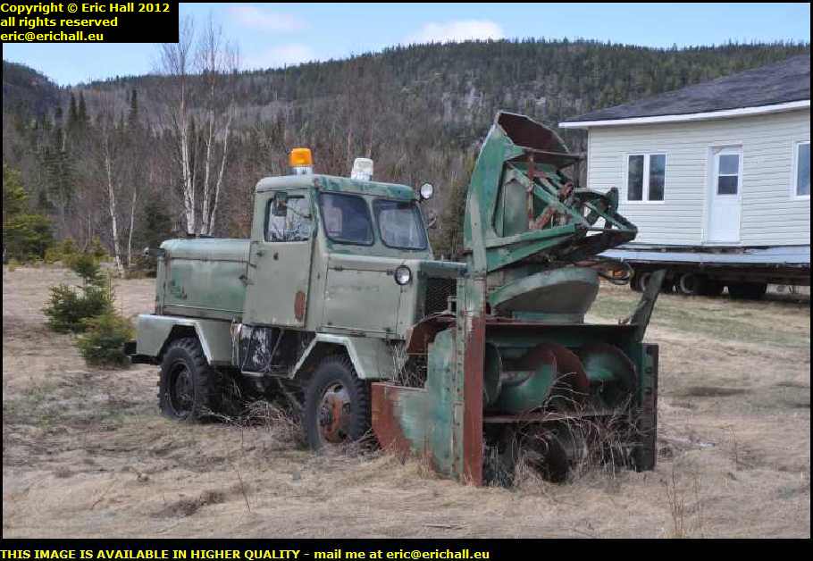
But here' a thing - do they really have so much snow up here at the back of Tadoussac that they need something like that? It's a beautiful machine though, isn't it?
But you would have to go out and move your snow only in a strong following wind or with a crosswind Try moving snow in a headwind and you would have all the output of the machine dumped on your windscreen or in your cab, or if the headwind were strong, it would blow over the vehicle back into the channel that you have just made and fill it up behind you - which rather defeats the purpose.
At the end of the little road we arrive at a section that gives all the appearance of an abandoned part of Highway 138. Turn right or left, and as I'm heading east (which is to the right), I turn right
<
You can't win a coconut every time can you? I end up in an impasse and have to retrace my steps. Luckily the other end of the cut-off is open and in one piece so I can rejoin the main highway there.
But before we move away from this photo and from Tadoussac, it's over there at that petrol station on the main highway where there is the left turn for Highway 172 down the Saguenay River. Mile marker 580 on Highway 138 if you are interested which I'm sure that you are.
Not only that, though, I made a mental note of this turn-off and it came in handy on a subsequent occasion when I was looking for a place to sleep for the night in the Dodge.
the diversion down the Saguenay
©