 | CANADA |
ET IN ARCADIA EGO
Two weeks later found me back on the road again.
I'd spent a very pleasant time with my niece and her family, not to mention her parents-in-law who are wonderful people. Canada was doing me some good. I'd recovered some strength and a bit of my health and I was truly sorry to leave the family.

Rachel drove me all the way to to Fredericton Airport where my hire car was all ready and waiting for me.
And I was in luck too. The company offered me the choice of some kind of Pontiac or else a Chevy Malibu. I'd had a Pontiac last year when I was in Wyoming and so this time I chose the Chevy.

Nice and white, it was. I wondered how long it would stay like that. Remember the Cavalier I'd rented two years ago that I'd managed to get thoroughly filthy after only two hours?
One thing surprised me, though. I'd ordered a compact, or an economy, can't remember which now. Well, whatever it was, the car that I exepced was the smallest and cheapest possible. I'm not sure what went wrong at the hire company offices but this doesn't look much like a compact or an economy to me. It makes me wonder what the big cars are like.
FREDERICTON
So off I set. Last time I'd been to New Brunswick (a few years ago now) I'd followed the Saint John River south to its mouth at the town of Saint John, and then gone down the Southern coast into the USA. This time I decided I'd do things differently and go across the mountains to the north-east coast and follow that coast down to Nova Scotia. Consequently I headed back up along the river and the abandoned railway line to Fredericton.

Here just on the outskirts of Fredericton I stopped to take a photograph of the bridge across the river. I'm into industrial archaeology, and some of my bridge photographs are present on sites throughout the web he said, blushing modestly. This particular bridge is the Princess Margaret road bridge, 1075 metres long.
I didn't cross by this bridge but took the Westmorland Street bridge further upriver. This gave me the opportunity to have a brief drive around the town. Quite neat, tidy and comfortable. Unfortunately you can't photograph a bridge that you're driving over (not easily anyway, and not willingly in a hire car, although I had no such inhibitions a couple of years later, and even now, a few years later, I'm still trying to work out why I didn't stop to take a photograph), so a photograph of that bridge will have to wait for another time. I was heading north.
The plan was to head along Highway 8 following the Nashwaak River up into the mountains of central New Brunswick, then over the top and down alongside the Miramichi River for a while as far as Quarryville, and then to go right over the top and through the wilderness to Bathurst.
It was a long way to drive in a couple of hours and it was getting late. Nevertheless, I had my eyes open and was prepared to stop to photograph anything interesting. After all, you never know what you're likely to find once you start to get into the more remote areas of this vast country.

I wonder what happened to the rest of this. I wonder what it is anyway. There were no identifying marks to give me a clue - not even a maker's plate that I could see.
Wreckage having duly been inspected, and photo having duly been taken, it was back on the road. And up into the hills. Incidentally, you can see why I always seem to have a hard time finding a travelling companion. I feel really sorry for Nerina, what with some of our French adventures during our marriage. Perhaps she's spread the word about.
Quarryville having been successfully negotiated (said he, having almost missed his turning not onece but twice) the next step was to get to Sunny Corner (quaint names they have round here - clearly land promoters of the 17th Century were just as unscrupulous as those today) and negotiate the peculiar junctions to find the highway to Bathurst. This took some doing and I was up and down the same bit of road three or four times, much to the amusement of the locals at the petrol station on the corner - this absence of signposts in North America really gets me beat - until the process of elimination and the position of the tea leaves at the bottom of the cup gave me some indication of the possible road out.

I can safely say I've never seen anywhere so dark as it was up there in those mountains. And when the metalled road gave out into a dirt track I can say I've never felt more alone either. This photo will give you some idea. Excuse the grainy finish, but it was the only way to throw a little light onto the subject.
No, this was seriously wild and desolate. Miles and miles of dirt track with just the odd light at the side of the road to indicate the turning to a mine of some sort. Once or twice there would be a mine complex that the road would pass through. These areas would be lit by some faded orange sodium lighting which seemed just to emphasise the emptiness and isolation up here (no-one was about up here - I didn't see a soul at all) and gave the area some sort of eerie feeling. Then you'd drive on into the darkness again.
I eventually picked up someone's tail lights in the distance, and followed them down the hill until we eventually reached a metalled road and civilisation.
Bathurst was only 10 miles away. I was glad I arrived here. I had had visions of spending the night driving round in circles on a mountain somewhere.
BATHURST
Bathurst is a fairly large town for New Brunswick, right on the Chaleur Bay. The first European to visit the area was Cartier in 1534 and the first settlers arrived in 1619. The modern-day settlement however dates from the Acadian expulsions of the 1750s. I had a good drive around in the dark and, as you'd expect, nothing seems to remain of any early construction. I was impressed by the huge harbour, even though there were no ships in it, but less so by the centre of the town. It was small, deserted, and there were few traditional shops. All the commercial activity seemed to be concentrated in a linear fashion along one of the roads that led out of the centre - a couple of miles of North-American chain store uniformity.
Motels and restaurants were sadly lacking in quantity, and I ended up with a pizza and a Comfort Inn.
Next morning was grey, damp and misty. Not as cold as it might have been either.

I decided not to take any photos of the town as there was nothing really that had caught my eye (and I'm not sure why - there are still one or two images that I have still in my mind's eye. I shall have to go back). I decided instead to head around the bay to Carron Point and get a photo or two of the town from there.
So here are the photos that I took. Rather a waste of time, really, as you can't see anything. There was far too much mist.

However you can see the attraction of Bathurst - a bay within a bay within a bay all protected by the headlands of the Miscou 60 miles up the road. There can't be many places as sheltered as this.
There are houses built right up to the waterline here so high tides or storms don't seem to threaten them too much, inferring that the bay is a safe and sheltered spot. I bet that many ancient mariners eould have been grateful to find a place like this to anchor after the treacherous crossing of the North Atlantic.
Anyway, I wasn't going back to Bathurst. "Onwards or upwards" as Jim Dale said in Carry on Columbus when he was discovering the New World. I was going on, and Bathurst will have to wait for another time. I was sure that there would be one.
Driving along the eastern shore of the Nepisguit Bay the first settlement I came to was Salmon Beach. Not a soul about, all quiet and deserted, it reminded me of a typical small village in the very south-east of England - the shingle beaches and the wooden shacks - holiday home type of places that you find along the sea shore in almost every western maritime country.
But where's the photo? Clearly I wasn't as well as I thought I was.
ISN'T THIS POUSSIN MY LUCK

20 Miles or so further on, having passed through several more of these deserted holiday village places, I came to Pokeshaw. Nothing much of interest there either except this rather unusual island. It is in fact known locally as Pokeshaw Island so I suppose it must have some claim to fame somewhere. It certainly looked impressive, that's for sure.
Driving along the road here, I noticed that many houses were displaying the Acadian flag, a pale blue cross on a white background, with a crest in the centre. The first time I'd ever heard of the flag, let alone seen one, and I can't understand why I didn't take a photo of one.
For the benefit of those of you who don't know about Acadia, this area was formerly colonised by France and was known as Arcadie. It fell to the British after Wolfe's victory over the French at Quebec and the fall of the citadel at Louisburg. To cut short a very long story many Arcadians were expelled to other parts of the French Empire (and this is the origin of the term Cajun in the area around New Orleans in the USA), only to be replaced by the Scots, many of whom had been expelled from their homes under the Highland Clearances, something that I find extremely ironic.
But I digress "You'll get used to this" - ed.
Next stop was the Acadian Village Museum near Bertrand a few miles further on . It was advertising itself as being open 7 days out of 7. Nevertheless, they must have heard me coming for when I arrived it was closed. There was nothing visible that was worth photographing.
I pressed on up the road to Caraquet for a coffee break, or what passes for coffee in North America. Only decent coffee I've ever had in North America was in Cheyenne in 2002, and nothing was to change on this trip. Having said that however, I had a superb cup of coffee in Charleston in April 2005 that beat absolutely anything I'd ever drank in North America.

Leaving the coffee to cool down for a while, I went for a walk around the harbour to look at the ships. There were quite a few here, mostly fishing vessels.
In fact all I ever seemed to see in Canada were fishing vessels and the reason for this became clear the farther round on my trip I travelled.

Note though how they all seem to be in good clean tidy condition. This makes quite a change for anyone used to seeing the average European fishing fleet. There seems to be more investment in fishing here in North America than in Europe - hardly surprising given the state of the fishing industry back home (
Of course I wrote all of this before I had encountered the devastation that was Cape Breton Island following the collapse of fishing on the Grand Banks).
MISCOU ISLAND
Coffee having been duly drunk, it was time to hit the road again - direction Miscou Island, the farthest point north on this voyage.

Until fairly recently the crossing was effected by a ferry - certainly in the mid 70s that was the case, but since then a bridge has been constructed. You can see how high they have constructed the bridge too - it needs go give a good headroom to vessels passing underneath.
There were a lot of bridges over all sorts of creeks and inlets on the way over to the island. It must have been a really time-consuming affair to travel the 25 miles from Petit Shippagan to Pokemouche in the old ferry days before the construction of all these bridges.
The island is really like one great morass of acidic floating peat bog. It was quite interesting to muse on the trees growing here with their roots firmly anchored in the floating debris.

It was certainly inhospitable here, settlements few and far between, in stark contrast to the previous 25 miles. Nothing at all about at the end of the trail at the tip of the island except the (unmanned) lighthouse.
Built in 1856 following several shipwrecks in the early 1850s, the lighthouse guards the entrance to Chaleur Bay and the sea lanes to Bathurst, Campbellton and Dalhousie. It was originally fuelled by seal oil (as I imagine a lot of things were around here at the time).

The other side of Chaleur Bay is the Gaspé Peninsula and the province of Quebec. Sometimes apparently you can see the Gaspé in the distance but it was out of the question today with the overcast conditions.

You can see from the photographs how grey, desolate and windswept it was around here today.
Nevertheless, it was a good place for me to have lunch and take a little walk.

Back in the car and retrace my steps all the way back to civilisation, Pokemouche and Highway 11.
One thing I was starting to notice here in the Maritimes was that almost every house had a fishing boat parked up in the garden. I suppose fishing is such a way of life around here that it's a secondary income (or even the primary income) of most of the inhabitants of the area. There doesn't seem to be too much else in the way of industry to support what appears to be a good-sized population out here on the eastern New Brunswick coast.

A little further on, near Inkerman, I came across what looked like an abandoned used car lot. Needless to say, the camera had to come out.
There were even more cars behind the hedge of trees and I was sorely tempted, but there was no-one around to talk to to ask permission to cross the "yard" to look. I really didn't feel like having to argue my position with the local police should someone summon them to find out what it was I was getting up to on someone else's private property. What with all this terrorism paranoia and hysteria that is currently sweeping North America right now, who knows where it could all end up?
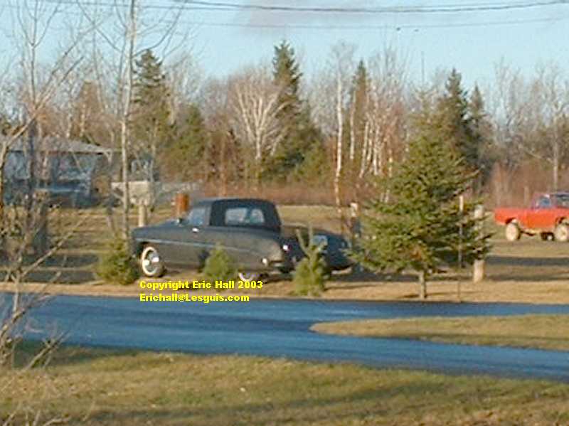
While we're talking about old cars (or at least, one of is) here's an interesting vehicle to photograph. I haven't a clue what it is but it seems to be some kind of early 50s saloon (sedan) cut down into a pickup. It was certainly unusual enough, that's for sure. I just wish they made telephoto lenses for digital cameras.
Sadly, it was the only thing of note worth photographing on the entire 60 mile drive between Pokemouche and the Miramichi city limits. Surely there must have been more than that? ( My excuse, when I look back on this trip, was that it was either too cold to get out of the car, too wet ditto, or that I was too ill to be thinking clearly. Probably more of the latter. Neither of the two former has ever stopped me before).
MIRAMICHI
So, what else can I find worth photographing at the Miramichi city limits? Oh, yes, a bridge. Good - oh! Have to take photographs of bridges.
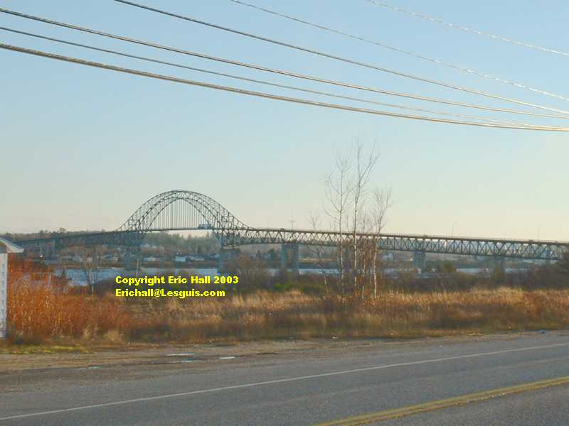
The Centennial bridge was opened in 1967 (there was a ferry here before) and crosses the Miramichi River (or more accurately, the tidal inlet that the river flows into on its way to the Northumberland Strait.
An interesting town is Miramichi. It's not really all one town at all.There's a "Chatham (Miramichi East)", a "Douglastown", a "Newcastle (Miramichi West)", a "Nelson - Miramichi" and a "Chatham Head". All really confusing. It's quite well-known as being a big lumber port. Lumber rafts used to be floated down the river to here in the past when lumber was much more plentiful up-country.

The town has a couple of claims to fame, all involving famous people. It was the former home of Joe Cunard (the brother of Samuel Cunard of the Cunard Shipping Line fame), former Canadian Prime Minister Dick Bennett, and also of Max Aitken (Lord Beaverbrook), the newspaper tycoon. Most surprisingly however, Bing Crosby's maternal grandparents came from here too.
Here's a photograph of the centre of town (of "Chatham (Miramichi East)" if I'm not mistaken) across the river from where I photographed the bridge. It has the air of being a typical North American "weatherboard" provincial centre with quite a bit going for it.
One thing it didn't have going for it however was any room at the inn. Every hotel or motel was either booked up or closed for the season (that'll teach me to take my summer holidays in November and December).

I had to drive out of town for several miles until I found a motel that was open. The Fundy Line Motel at Newcastle. Still I wasn't disappointed. It was a reasonable price (45 Canadian dollars plus taxes) and quite adequately appointed.
It even had a restaurant attached but by the time I was hungry, it had closed. Typical North America. I ended up having to eat a plate of greasy fish and chips in some local fast-food fish-and-chip diner of which I forget the name. Still, you get what you pay for, so I shouldn't complain at the price that I paid.
Next morning saw an early start for once, and it was back on the road again. Back over the bridge and along the south shore of the Miramichi Bay to Escuminac (25 miles away) and round via the Kouchibouguac National Park to Highway 11 to follow the Northumberland Strait.

This photograph shows the memorial to the disaster at Escuminac on the night of 19/20 June 1959 when 35 sailors lost their lives in a storm that swept the fishing fleet of this small town. It also records the deeds of heroism that were performed in rescuing survivors.
The memorial was unveiled 10 years later, in 1969. The first subscriber was Lord Beaverbrook, he of "Miramichi fame, and the memorial was unveiled by his son Max Aitken, the well-known British newspaper publisher. Some more information can be found at this site. You can see from this site how dependent the Maritimes used to be (and still are, in fact) on fishing and the sea as a way of life, and how these small communities suffered in the numerous seafaring tragedies that afflicted them.
The drive from Escuminac back to Highway 11 was fairly uneventful, especially as there was nothing at all going on at the "Koochie", as far as I could see. The salt marshes of the Kouchibouguac National Park are home to over 200 types of bird, so they say, but I bet there isn't one single type of bird that I'm likely to be interested in watching.

Once back on the highway, I turned off again for Cape Lumiere to see if I could get my first glimpse of Prince Edward Island.
This is the village of Cape Lumiere (or, more correctly, Cap Lumière seeing as we are in the French - speaking part of New Brunswick). Once again, there's not a soul about at all.
You can see what I mean though about these small coastal villages of wooden chalets here in the Maritimes, that resemble a typical Romney Marsh village in South-Eastern England, by looking at the photograph here on the left.
I TEGO ARCANA DEI

From here, I drove on a little way down to the harbour for a quick nosy around, but that was almost as deserted, not a single fishing boat in sight.
There were however a couple of men busy carrying out some kind of repair to the structure of the quay using a JCB (or whatever its North American equivalent is) and a pontoon, so I sat and watched them for a while whilst I ate my lunch.
Well, it was free entertainment and passed the time. I suppose I was secretly hoping that one of them might fall in, but no such luck. Never mind. Being the typical Pisces, I can get all enthusiastic about sitting and watching the sea, even if there is nothing particular going on.

Lunch having duly been eaten (and I've forgotten what it was that I ate, it was so interesting), it was time to look out for Prince Edward Island. Down at the harbour you could see nothing at all, so I had to drive a little way further on up the road to get my first view. You'll need to click on the image to see the larger version in order to get a view of the island across the Northumberland Strait.
Not a very good photograph I'm afraid, but it's only a cheap digicam (a Fuji end-of-range special) and you can't make silk purses out of sows' ears.
As you've probably gathered by now, I have rather an unhealthy interest in bridges, and the ones here in Maritime Canada are certainly more interesting than most (well, at least to me they are, anyway).

This photograph is of a typical Maritime wooden bridge, one of many built in this style across rivers here. Even the road surface is made of wood.
This particular bridge is over the River Cocagne, not too far from the town of that name. For the benefit of the non-francophones, "Cocagne", or more correctly, pays de Cogagne is the correct French translation for the "land of plenty", but the only things I saw plenty of were not the things that I would name a town after, especially if I were trying to sell my colony to unsuspecting immigrants.
There is however another translation of the word "Cocagne", the mat de cocagne, which means "greasy pole". By that I don't mean the slippery customer from Warsaw, but the type that you try to climb up at a fairground, but always slide back down to the bottom. That explanation is much more appropriate for immigrants from Europe who had come to settle around here in the seventeenth and eighteenth century and were trying to get rich from this land.
CONFEDERATION BRIDGE
Mind you, for bridges to end all bridges, there's a famous one about 50 miles away - the Confederation Bridge that links Prince Edward Island to the mainland at Cape Tormentine. A slow drive (with nothing interesting to photograph on the way) took me there.

One of the conditions of the union of Prince Edward Island with the rest of Canada in 1873 was the provision of some kind of all-year-round connection between the island and the mainland. Doubtless a bridge was pretty high up on the agenda despite the distance (this was in the days of the glorious Victorian engineers such as Thomas Bouch who was busy building the Tay Bridge in Scotland at the time) as the Northumberland Strait ices up in winter. Nevertheless there were many considerations (probably the collapse of the Tay Bridge was one and the collapse of James Brunlees' Solway Viaduct, by an ice floe as it happens
, was another - never mind the simple fact of the cost of a bridge over here) so a ferry was the preferred option, even though it wasn't until 1912 that a reliable "ice-cutter" ferry was able to make the permanent connection.
The bridge came back onto the agenda in 1982 however and 12 projects, for both bridges and tunnels, had been submitted by the deadline of 1987. Part of the deal was that the bridge would be self - financing, through the collection of tolls, until the construction was paid off (between 30 and 40 years). The winning project was unveiled in 1992.

Meanwhile the idea of a bridge became one of the most controversial construction projects in Canada in modern times. Even the owners of the bridge admit that
"On P.E.I., this decision .... brought the simmering debate over a fixed crossing to a fast boil. Many Islanders applauded the decision; many others were aghast".
Part of the problem was the fact that some islanders were afraid of losing their heritage and individuality. Others were afraid that the island would be overcrowded with settlers from the mainland. One group considered that no bridge would withstand the icing stresses; environmentalists feared for the destruction of the local ecosystems, and the fishermen were concerned that the lucrative fishing grounds in the area would be devastated by the construction and operation of the bridge. These latter, maybe more than the "NIMBYs", had a valuable point - you can't spend five minutes here without realising how important the fishing industry is to the local economy. And hundreds if not thousands of locals had sacrificed their lives to the catch.
A referendum was held, and the final vote was 60:40 in favour of the bridge. Construction commenced in 1993 and the bridge took three years to build. Made of concrete box girders and eight miles (thirteen kilometres) long, its total cost was in the region of one billion Canadian dollars.
One thing that can be said in its favour was that over 5000 jobs were created during its construction. It was opened to the public in the spring of 1997 and the all-year ferries that had sailed from Cape Tormentine to Border-Carleton closed down.
I was intending to travel to Prince Edward Island but not by the bridge. There is another way to cross the Northumberland Strait (well, more than one way if you include flying or swimming, but they weren't the ideas I had in mind).
First things first though - find some accomodation. The light was starting to go and I doubted there would be any accommodation until either Amherst (30 miles) or Moncton (50 miles).
Ahh - now what's this? A motel? And at Melrose. Only a couple miles away from the bridge too.
It was still light too when I arrived but at least staying here meant I didn't have to undertake any lengthy detours. A good decision too as the rates were quite acceptable and there was a restaurant attached. I made sure I went to eat before it closed. It's a long way to a town of any size if I miss the restaurant.

Next day it wasn't going to be a long drive so I had a bit of a lie-in. Leaving the motel at about 10 o'clock I fuelled up (the car with petrol and yours truly with coffee) just down the road at Port Elgin and then cut off down a little road over the Tidnish Dock Provinvial Park to the town of Tidnish.
I took a photograph looking out across the marshes of the Park and over the Chignecto Isthmus and Baie Verte to Port Elgin and Upper Cape. Distance shots unfortunately not working too well this morning. Shame.
Just down the road I crossed into Nova Scotia.
©