 | USA - SEPTEMBER 2002 |
LEAVING SANTA FE
There was a choice of routes to take on leaving Santa Fe. I didn't want to go back up the Interstate to Denver - that was the way I'd come south. Some people I'd met suggested that I go north on Highway 285 which was a wide fast road that would take me ultimately onto Interstate 70 where I could go east to Denver. I didn't have any better plan for the moment, so that was as good as any, so that was what I did. Things would sort themselves out as the journey continued.
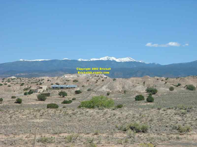
The last couple of nights I'd noticed that it was feeling colder, and here for the first time on this journey, on the peaks of the Sangre de Christo (Blood of Christ) mountains, I saw snow. A reminder that it may well be only 20th of September but summer had gone and winter will soon be here.
Seeing snow like this always makes me think that someone has dipped a paintbrush in a pot of white paint and painted a quick brush stroke across the mountains.

This on the right is a typical rural New Mexico scene that you see this time of the year (and maybe other times of the year too) along the verges of all the New Mexico highways - the chili wagon.
The interesting thing about driving around, as I do, without a guide book, without an itinerary, and only a couple of cursory glances at a loosely-held map, means that if you aren't where you're supposed to be, then you're always somewhere else. It's probably more interesting than where you were going anyway. You can always extract yourself out of it later and still make the plane (and if not, well, there's always another plane anyway).

Consequently, after an hour or so of driving northwards and finding myself on Highway 68 instead of Highway 285, well, so what?
At least I was able to find the Rio Grande, the third-longest river in the whole of the USA, although it looked a lot smaller here than I imagined it would be. A Rio not very grande at all, in fact.

Anyway, like I said, taking the wrong road is no big deal. At least it gave me the opportunity to have a good drive up into the foothills of the mountains.
Here you can see the road I climbed up, and how much it winds itself out of the valley which you can see way, way in the distance. This has to be much more interesting than driving along Highway 285.
TAOS

These mountains form the backdrop to the winter resort town of Taos. The snow has already arrived and the skiiing will be shortly getting under way.
They say that Taos is one of these "chic" places to see and be seen. Full of trendy shops, boutiques and so on so I thought the Muzzy and I wouldn't be out of place here.
It was also the home of trendy people too. People like Mabel Dodge Luhan, DH Lawrence, Georgia O'Keeffe and Millicent Rogers all lived here. Lawrence's ashes are interred up in the mountains behind here too.
There's also a famous pueblo here, that is alleged to have such an aggressive policy with regard to tourists that many folk have made complaints. The most common complaint is that even if you stop your car for 10 seconds to look at your map, you are slapped a hefty parking fee. I suppose that this is the American way of attracting custom to your town. But not me. This kind of thing gives me the shivers.

It was all irrelevant anyway. I couldn't see anywhere to park along the main road, and I wasn't going to make a special effort. There was however an exhibition of Ford "A"s (more than three of them, anyway) so I took a quick snap whilst I was waiting at the traffic lights. The best I could do.
Time to head back to Highway 285 I reckoned, and Taos was as good a place as any to turn left. This meant a quick blast down Highway 64 to Tres Piedras, but like anything else, there's always this tendency that I have to become distracted.
HIGHWAY 64 - THE JACK M CAMPBELL HIGHWAY

I mean, any old signpost is good enough to make me stop to read it. But having read it, I wondered why I bothered. Apparently Highway 64 is the "Jack M Campbell Highway", whoever he was.
In fact, Jack M Campbell was born in Kansas in 1916. He was a Special Agent for the FBI and served in the Pacific theatre with the Marines during Word War II. In 1946, he took up the but was essentially a committe man for several trade organisations. In 1956 he entered formal politics, holding many positions in the New Mexico House of Representatives before being elected State Governor for the period 1963-1967. He died in a nursing home in 1999.
According to the sign, "This road passes through some of the most spectacular scenery in the American southwest". If you have been following my website, you will realise that this claim is total garbage. If you saw my drive along Highway 89 and Highway 12 in Utah or the Valley of the Gods then this place is even worse than banal. So much for hype. As for the snow-covered mountains, we have seen some of these already this afternoon.
Rio Grande Gorge Bridge

Nevertheless, just by the aforementioned signpost, the highway passed over the Rio Grande by this beautiful arched bridge that you can see on the left - the Rio Grande Gorge Bridge. It's 1272 feet long and 560 feet above the river. Built in 1966, it was voted the most beautiful bridge in the USA for that year. Yes, it would get my vote too!
They say that the area around here is well-known for white-water rafting, and the river itself gets 5 stars. In my opinion, if it's graded heavily for white water rafting, it should receive 5 exclamation marks, just like the brothel in Carry on Spying - but of course that was for other reasons.
Many people think that the winner of a white-water rafting race is the raft that finishes first. This is not true. it is a little-known fact that the winner is the raft that finishes with the fewest people still on it.

Yes, the river really is 560 feet down there. I know it doesn't look like it in the photograph, but I can assure you that it does in real life.
Here on the bridge I had one of those amusing moments that only ever occurs probably once every Preston Guild. I was standing behind two women, and I overheard one say to the other
"Ik findt het heel mooi"
So I couldn't resist it "Ik findt het ook geel mooi"
Now that was a conversation-killer. They both looked at me for what seemed like a week.
Finally one of them spoke up "Uw komt ook uit Nederlands?"
"Nee"
(Slight pause)"Amerikaner?"
"Nee - ik kom uit Wales"
and on that note I walked away.

They're probably still wondering now what on earth a Welshman who speaks Dutch was doing in the USA standing on this bridge miles from anywhere at exactly the same time that they were there.
Actually, I quite like the Dutch, even though they don't have a word in their language for gratis, as the bushbaby could well say.
I only half-agree with Michael Caine who on one famous occasion said "there are only two things in life that I can't stand. People who are intolerant of other people's cultures ... and the Dutch"

Here on the left, though, was something that gave me no pleasure at all to see.
This is the boundary of the native American tribal lands, and there was a sign up to prevent trespassing. But I couldn't help feeling disappointed to see that it was fenced in with barbed wire. 135 or so years ago when the white man started to occupy Indian lands the first thing he did was to put up barbed wire to keep his cattle in and the native American and the buffalo out - and how much anxiety it caused at the time. A few years later when the native American was expelled, firstly they were all rounded up just like so much cattle, and penned in barbed-wire enclosures before setting out on the trek to Florida.
If it had been me, I'd have had enough of this barbed wire to last until eternity, and I'd have used something else to use as a boundary marker. Seems rather strange to spend years fighting and killing to protest about fencing off the prairie, and then when you get some land of your own, first thing you do is to fence it off yourself.
It's rather like Zionists who spend 50 years trying to make the world never forget that they spent 5 years walled and fenced in ... and then build a wall and a fence to fence themselves in. I've just no idea what kind of crazy, distorted logic is behind that.
EARTHSHIPS

It was the solar array here, about 15 miles from Taos, that gave me the clue - anyone with a solar array like this has to be worth talking to. When there is a wind turbine too, then so much the better. Even if the wind turbine doesn't have any blades and isn't coupled up to the electricity.
I can talk (as you may have realised by now) and I hadn't come all this way across the Atlantic to miss out on talking to the kind of people who might live here.

I have a passionate interest in wind and solar energy, and I'm always ready to give three cheers to anyone with a solar array somewhere on their property. So let's hear it for the solar panels "hip, hip, array"
These buildings are known as Earthships

So, what is an Earthship?
Well, it's a residence made out of all sorts of waste products and rammed earth, specially designed and built to maximise the natural effects of the sun, and to make the most out of as little energy as possible.
lick on the photo on the left to see an enlargement, and then you can read some more about it. When you have finished, click on the "back" button afterwards to come back.

On the next two photographs, you can see an "after" and a "before"
To begin, you pile up your collection of used tyres, build a wall, then ram it full of earth under compression, and seal the joints with empty beer cans.
On the outside, you would normally plaster over it to keep out the weather. On the inside, you'd do the same to make it aesthetically pleaasant. This was inside a storeroom, though.

On the left you can see that the tyre wall isn't a complete circle. Here, you would normally put a large window in order to let in as much light and heat as possible. You can see that the others all have large south-facing windows.
The earth and tyre walls would absorb the solar heat during the summer, and in the winter would allow the heat to radiate into the living area during the winter.

Now, this is an interesting and novel idea of what to do with your empty beer bottles. Well, I suppose it gives you an excuse to carry on drinking

If it's your idea of a good time, you can rent an earthship for a few nights to get used to the idea of living so close to nature. This one on the left is quite cute. The idea certainly appeals to me, but I don't know if I could ever find the time to stay still for more than five minutes.
So, thanks to everyone at the Earthship for taking the time and trouble to talk to me, and the very nice young girl who showed me around the main ship and the small visitors ship down the road. I just wish I was 20 years younger.
I had a long way to go. I had to go. But you don't have to. You can hang about and read some more about the earthships.
HIGHWAY 285
I came up to the road junction at Tres Piedras and turned left. As I did so, a gust of wind blew into the cockpit of the car, sucked up the map that was lying calmly on the passenger seat, and blew it out onto the roadway.
No traffic about (not like a British road, then!) so a beautifully - executed handbrake turn, even though I say it myself, followed by another even more beautifully - executed handbrake turn, even though I say it myself, and I was able to pick up the map without even getting out of the car. Impressive, hey?
It was then that I noticed that I was back on Highway 285 - but going south, in precisely the opposite direction as advised. Now why is no-one surprised by this?
So why was I going south instead of the more logical north?
Ojo Caliente

This is why. Ojo Caliente - or Hot Springs.
This is not to be confused with the "Ojo Caliente" in southern New Mexico near Truth and Consequences (yes, that's a REAL town name) which was the famous haunt of Geronimo and his Chiricahua Apache.
Well, so what if some of us (okay, one of us) did? I'm just an ignorant foreigner and I know nothing. It's your own fault for having two places with the same name in the same state.

Reminds me a bit of the scene from "Casablanca".

Nevertheless, it was certainly an interesting detour to make and quite a beautiful place to walk around for 15 minutes, as you can see from the photographs. I can well understand why people would want to come here for the peace and quiet and to "take the waters".
You couldn't mistake the overpowering odour of sulphur here at Ojo Caliente - not to mention the odour of various other chemicals too. A couple of laps around this swimming pool and you'll have cured all diseases known to man (and quite a few unknown ones too, I bet).
Rather like the story of the Irish scientists in fact. They are alleged to have invented a cure for which there was no known disease.
They also invented a liquid that dissolves everything with which it comes into contact. They are now trying to invent a container to keep it in.
Along similar lines, you know what the "c" and "f" mean on taps in the bathroom of Mexican hotels? Well, the "c" means "cold" and the "f" means "freezing".
Leaving here I was faced with a serious choice. Where to go next. I'd two days left and I wanted to use them to the best advantage possible. I had planned to hand the Muzzy back tomorrow and spend a day wandering around Denver, but sod that for a game of soldiers. I was having far too much fun in this car, so I was determined to hang on to it until the last possible moment - even if it meant a hefty excess charge. There are some things that just don't have a price.
So where to next? After a lengthy discussion between me, myself and I (yes, you're never alone with schitzophrenia, and you think you are never alone with paranoia either, for that matter), we came to a conclusion. Although I'd been invited to Telluride, that looked just a bit too far away and too awkward to get to. In fact I'd chosen Santa Fe over Telluride. How about Carbondale?
Yes. I could go to see some friends I'd made from the Solar Energy Institute in Carbondale. And if I were to follow the straight line that I had just drawn on the map between Ojo Caliente and Carbondale, I discovered that I would be driving over some beautiful country and some mountain passes that looked absolutely wonderful. Rather like the Canjilon Pass through the Carson National Forest, in fact.
THE CANJILON PASS
A drive of about a mile of two north of Ojo Caliente would bring me to where I needed to turn onto the 554 to El Rito, and then over the top.
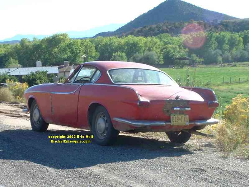
And the first thing I saw after I had turned was a Volvo P1800 parked by the side of the road. You can see by the "cowhorn" bumpers, or fenders or whatever you call them that it's one of the early Jensen-bodied model.

I took this series of photographs to annoy my friend Paul Humphries back in Stoke on Trent. You see, round about the time I was taking this photograph, he was busy cutting up a P1800 in a much better condition than this one.! He just wouldn't believe that there would be one as bad as this still on the road and driving.
And neither would I, to be honest.

In Europe, as I've told you before, every vehicle over a certain age (in the UK it's three years) has to have a technical control from a Government-approved testing station to check its general roadworthy state, its overall condition and its emissions. In the UK and Belgium it's every year whereas in Germany and France it's every two years.
If this went for a technical control in Britain it would be laughed at. If it were pulled over for a spot-check, the police would have it straight off the road in this sort of condition.
Body filler and thick paint is not the answer to "preserving" old motor vehicles in Europe, and to see a vehicle such as this that someone has let get into such a terrible state - well it makes me want to cry. But even body filler and thick paint would have been some use in certain other circumstances that I had encountered on my travels.

Driving up the mountains to Canjilon was another one of those dirt track roads that didn't have the air of being too difficult to pass. It was rough, that's for sure, but not as bad as the Moffat Road.
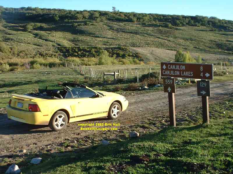
What I had to bear in mind though was that the Mustang didn't have the ground clearance of the Pontiac.

High up in the mountains there was a great deal of water on the road, and I was obliged to drive through a couple of floods. You can see that the Mustang became a little ... well ... you know what I meant, but I kept slowly plugging away.
A bit further up, a couple of guys coming downhill in a 4x4 saw me coming up towards them in the Mustang. They looked at me for a moment, then at the Mustang, then at each other, and then finally they stopped me.
"I don't think you'll get through in that - there's a washout further on"
This was a turn-up for the books.
"I'm trying for Canjilon. It's not that way, is it?"
"Canjilon - you might be lucky. But make sure you turn left in a couple of miles. Don't whatever you do turn right. Thats where it's flooded"
So having thanked them, I continued on up until I came to a left turn, and promptly turned left.
And by hell, that road was rough. It became narrower and narrower, and rougher and rougher, and I started to knock the floor about no matter how I tried to get round. After 10 minutes of this, and a walk further up the hill for a few hundred yards, I realised that there was no future for us up this road, so reluctantly I turned round and, for the first time, gave up. I really thought I had met my match here.
When I got back down to where I'd turned off, I stopped and had a little think.
Those guys had said "turn left - don't turn right", yet here there isn't a ""right" to turn. It's either "left" or "straight on". I wonder if I'm in the right place?
So I drove on another 200 yards and there was this "T" junction, with a right turning signposted "Vallecitos" and "Canon Plaza", and a left turning clearly signposted "Canjilon". Silly bugger - I'd taken the wrong turning. Later research showed me that I'd tried to drive up a cattle track through the forest to the summit of Magote Peak.
Well, the Muzzy and I finally made it to the top of the mountain, as you can see. It was well worth the sweat to get all the way up here. I had to take a couple of photos for posterity. "I was there", as the legendary Max Boyce would say at moments like this.
You can see for yourself in these two photos that the views from up here were really superb.

Just like Alan Parsons,
"I see the world"
"And I'm looking from a high place"
"Way above it all"
"Standing on higher ground"
But I'm really going to have to get up here earlier so that the sun is in a different direction, or buy myself a better camera to make the photos even better. And when I've bought one, I'm going to go back to do the drive again!
In fact, January 2007 saw me take possession of a digital SLR". I'm going to be really busy for the next few years retracing my steps, aren't I?
So down the hill to the bottom, miss my turning, be pointed in the right direction by another couple of good old boys, and finally Highway 84, heading north. Foot down in the Mustang - the light was going, and I felt like I could do with a good coffee. Gotta keep moving on
©